High Tech & Software Startups
#Space
#Security
#Defence
#Satellite
Crowsourcing Annotation Software for SATCEN
1
Happy client
3
types of users
6
months of development
9
versions of screens
Crowdsourcing Data Annotation
In the ever-evolving landscape of UX, UI, and software development, the demand for high-quality data annotations has grown exponentially. Crowdsourcing, a powerful and popular method, has emerged as a game-changer in acquiring annotated data for applications such as natural language processing, computer vision, and machine learning. Crowdsourcing data annotations is a collaborative process where a diverse group of contributors label and annotate data through crowdsourcing platforms, enabling cost-effective and scalable generation of labeled data for various applications. Using user-friendly interfaces provided by these platforms, contributors access and annotate data based on predefined criteria. This could entail anything from labeling objects in images to transcribing speech in audio recordings. The results of this collective effort are then aggregated to train machine learning models for applications like natural language processing and computer vision.
Cost-Effective Scalability: It enables organizations to quickly accumulate vast amounts of labeled data at a fraction of the cost compared to traditional methods.
Swift Turnaround Times: With the support of a large contributor base, crowdsourcing platforms guarantee faster project completion, making it ideal for time-sensitive endeavors.
Diverse Expertise: The crowd brings together diverse perspectives and expertise, enhancing the quality and accuracy of annotations. This diversity, in turn, promotes a more comprehensive understanding of the data.
Accessibility and Transparency: Crowdsourcing democratizes the data annotation process. It opens the door for anyone with an internet connection to contribute, irrespective of their location or financial background. This not only promotes transparency but also enables participation around the clock.
About SatCen
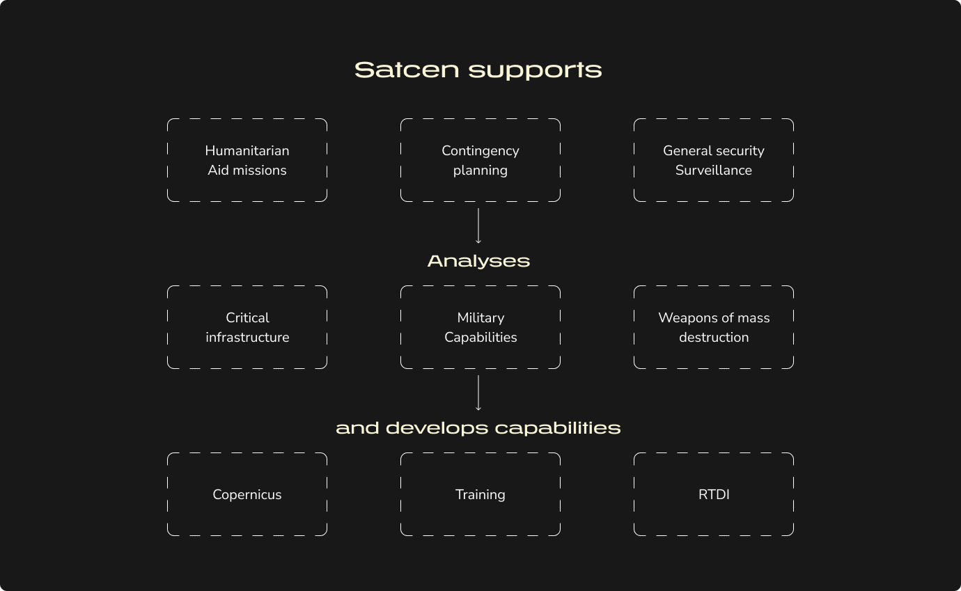
The European Union Satellite Centre (SatCen) is an Agency of the Council of the European Union. It supports the decision making and actions of the EU in the context of Europe’s Common Foreign and Security Policy by providing products and services resulting from the exploitation of relevant space assets and collateral data, including satellite imagery and aerial imagery, and related services.
Beneficiaries of SatCen services are the European External Action Service, EU Member States, CSDP missions and operations, the European Commission, Third States and international organisations such as the UN, OPCW and OSCE.
#innovative developments, from #AI integration to #geospatial intelligence products

Leading provider of geospatial data and technology solutions, approached our team with the ambitious goal of developing an AI-Ready Annotation Software for Satellite Image Labeling. The client sought a powerful, intuitive, and efficient tool that would simplify the process of annotating satellite imagery, enabling better AI model training for various applications, including environmental monitoring, agriculture, and autonomous systems.
Complex Annotation Workflow:
Challenge: Annotating objects in satellite images can be a complex and time-consuming task, given the wide range of object sizes and the need for precision.
Solution: We designed a user-friendly interface that allowed users to choose from multiple annotation tools, making it easier to select objects, define their shapes, and add descriptive labels. This streamlined the annotation process, reducing the complexity for users.
Data Quality Assurance:
Challenge: Ensuring the quality of annotated data was essential to SATCEN clients, who relied on the AI models trained on this data for critical decision-making.
Solution: We implemented built-in quality control features, allowing users to review and validate annotations. This not only improved data quality but also reduced the need for post-processing and error correction.
Descriptive Labeling and Metadata Integration:
Challenge: To make the dataset more informative, users needed to add detailed descriptions and integrate georeferencing information.
Solution: We designed an intuitive labeling interface, allowing users to easily describe the subjects within the images and seamlessly integrate metadata. This increased the utility of the annotated data for a wide range of AI applications.
Results
Efficiency and Productivity:The new annotation software reduced the time required for annotating satellite images by up to 40%, enhancing the productivity of data scientists and researchers.
Clients could complete their projects more swiftly, leading to increased operational efficiency and faster insights.
Improved Data Quality:
The built-in quality control features significantly improved data quality, reducing errors and inaccuracies in annotations.
Clients experienced higher confidence in the data they used for AI model training, resulting in more accurate predictions and insights.
Versatile Data Integration:
The multi-format support and georeferencing capabilities made it easier for users to work with different satellite image sources.
This versatility expanded customer base, accommodating a wider range of data providers and applications.
ABOUT APPLICATION
The AI-Ready Annotation Software for Satellite Image Labeling is a powerful tool designed to prepare data for artificial intelligence (AI) applications by annotating and labeling sections of satellite pictures. This software streamlines the process of selecting objects within these images and providing detailed descriptions of the subjects, making the data ready for machine learning and computer vision algorithms.
Key Features
Image Annotation:
Precise Object Selection: The software enables users to meticulously select objects or regions of interest within satellite images, ensuring accurate annotation.
Polygon and Bounding Box Tools: Users can choose from various annotation tools, including polygons and bounding boxes, to define the shape and location of objects within the images.
Scalable Annotation: The software is equipped to handle a wide range of object sizes, from small features to large structures.
Descriptive Labeling:
Subject Description: Users can add descriptive labels and text annotations to the selected objects, providing context and information about the subject matter.
Metadata Integration: The software allows for the incorporation of metadata such as timestamps, geospatial coordinates, and other relevant information, enhancing the dataset's comprehensiveness.
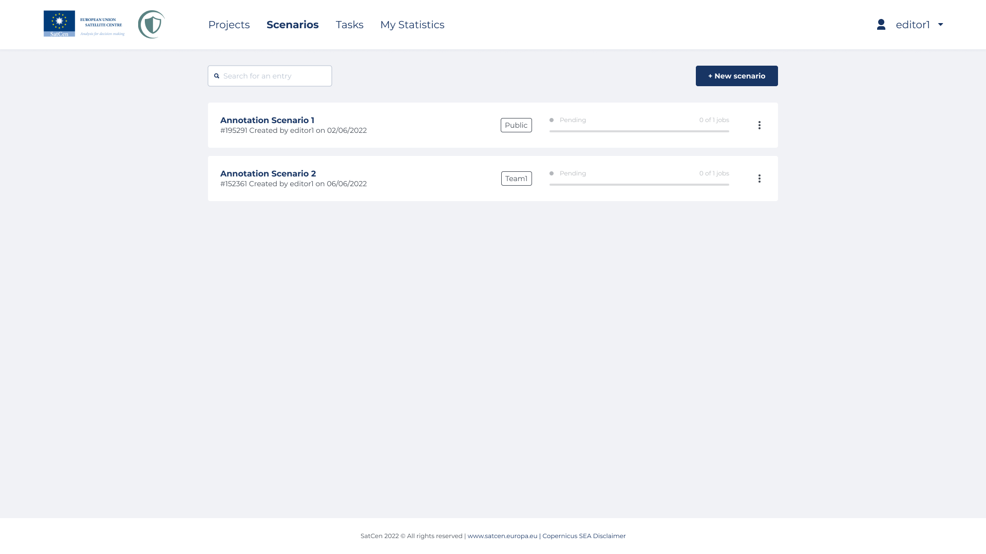
Multi-Format Support:
Compatibility: The software is capable of handling various satellite image formats, including common file types like TIFF, JPEG, or proprietary formats from specific satellite providers.
Georeferenced Data: It can integrate georeferencing information to ensure the spatial accuracy of annotations.
Collaboration and Workflow:
User Collaboration: Multiple users can work on the same dataset simultaneously, making it suitable for teams and collaborative projects.
Workflow Management: The software includes features for tracking the progress of annotations, managing datasets, and maintaining version control.
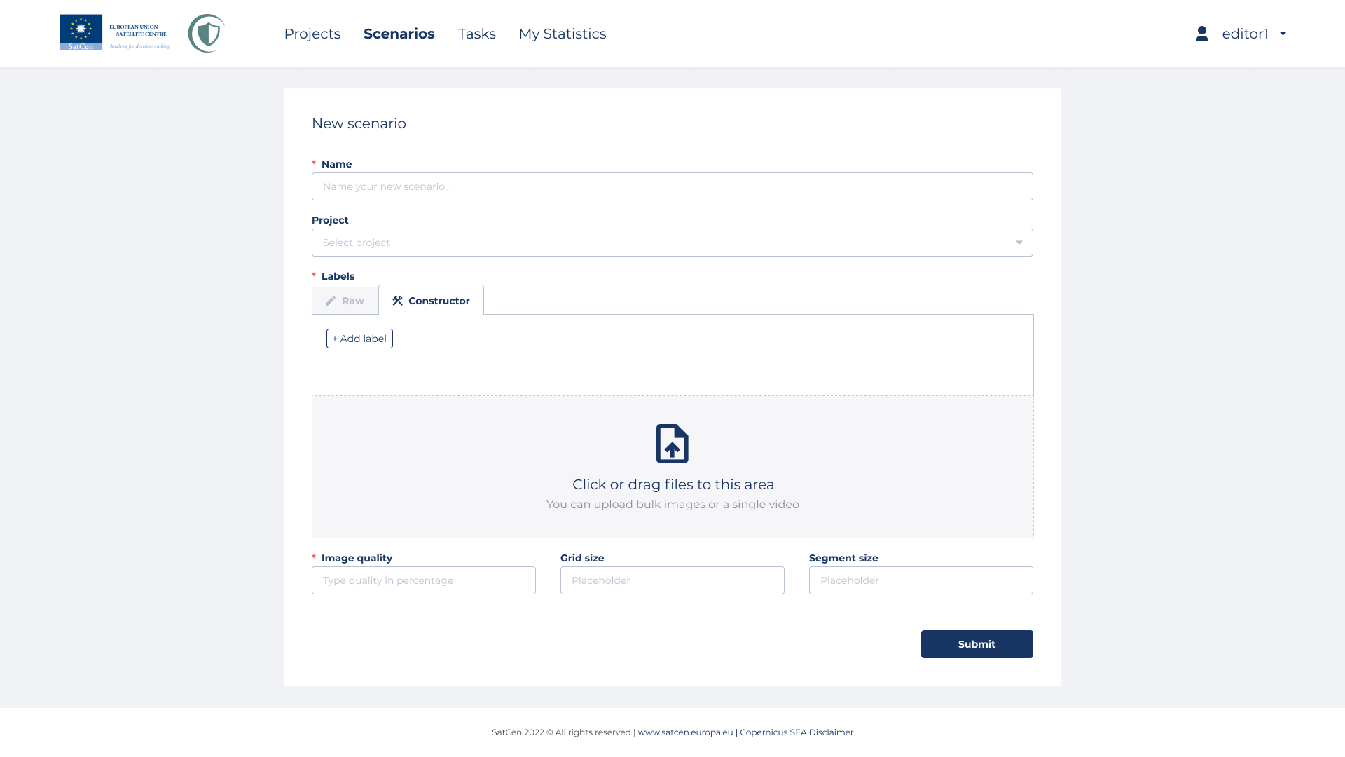
Quality Assurance:
Review and Validation: Built-in tools for quality control allow for reviewing and validating annotations, ensuring high-quality training data for AI models.
Error Correction: Users can easily correct any inaccuracies or errors in annotations.
Export and Integration:
Export Options: The software supports various export formats, making it easy to transfer annotated data to popular machine learning frameworks and tools.
API Integration: APIs are available for integrating the software into custom AI pipelines and workflows.
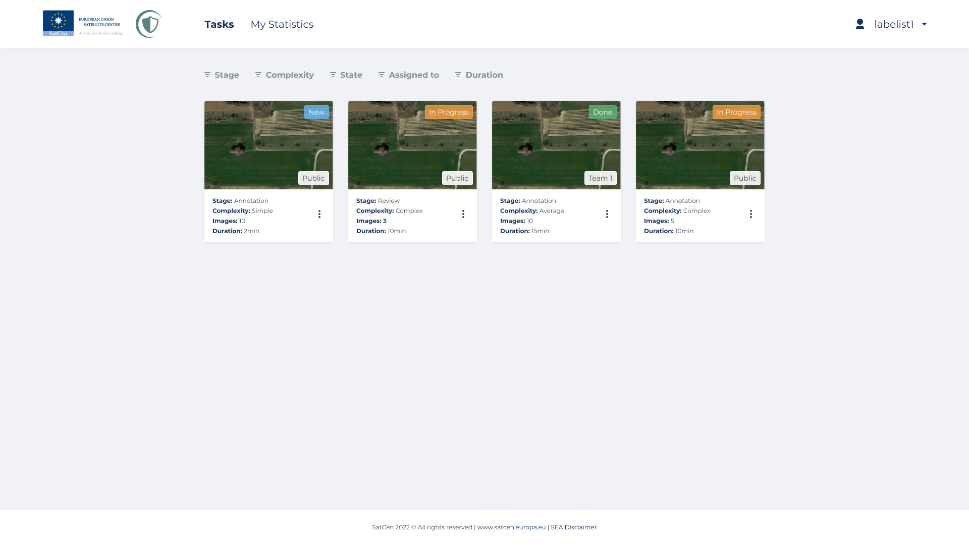
Applications:
Earth Observation: The software is particularly valuable for annotating satellite images used in earth observation applications, including urban planning, environmental monitoring, and disaster response.
Autonomous Systems: It supports the development of AI algorithms for autonomous systems, such as self-driving cars, drones, and robotics, by providing annotated datasets for training and validation.
Agricultural Analysis: Agricultural experts can use this tool to annotate satellite imagery for crop health assessment, land use analysis, and precision agriculture.
Security and Defense: Annotated satellite images are essential for defense and security applications, aiding in surveillance, threat detection, and situational awareness.